Winter surveys - Timed 1-hour surveys
In order to estimate relative abundance and make comparisons across blocks, surveys need to be standardized in some way. The easiest way to do this is to have a fixed survey time, so we are asking atlas volunteers to break up their total survey effort into a series of separate one-hour observation periods. Each observation period should be exactly one-hour long and only those birds seen or heard within that period should be included. Other interesting birds can be recorded as incidental observations (see below). These one-hour survey periods should be spread out to survey different parts of the blocks and different habitats. If you want to spend longer birding for the atlas on a given day, feel free to conduct consecutive observations, but please record the data separately for each hour and for the specific area covered.
Protocol
- Identify 5-10 sites within your block, chosen so that they span a range of habitat types. A site should be an area you can search on foot (or similar – a kayak or small boat would be fine) within an hour. Do not chose just the best or most well-known sites, but ensure your set of sites represents the range of habitats present in the block. Including lakes, ponds, and shorelines is fine, but consider doing specialized surveys on these habitats as well. A site can be anything from a public park, a walk through a neighborhood, a trail through the woods, a length of beach, etc.
- Timed surveys should not be conducted in a car, as you will miss more birds that way. Nor should they be stationary. Records from feeder-watching should be submitted as incidental observations.
- Visit each site for a timed one-hour survey sometime in November or December, and then again in January or February (i.e., a total of two visits per site). If you have a countdown alarm on your phone, use that to ensure you do not spend longer than an hour.
- Surveying multiple sites on the same day is fine. Similarly, if there is one large area that has a variety of habitats and would ordinarily take more than an hour to survey thoroughly, then it is ok to subdivide it into sections, each of which is considered a separate site. For example, one could divide the portion of Hammonasset State Park that lies in block 98F into three areas (e.g., Meigs Point area, central rotary area, west end area) and visit all three in the same morning, spending an hour in each. Each one-hour survey should be submitted as a separate checklist. Other interesting birds seen outside these one-hour blocks can be reported as incidental observations.
- During each hour-long period, survey the chosen site on foot, counting all birds seen or heard, while doing your best to avoid counting the same individuals more than once. We are looking for a count of the number of different individuals of each species that you detect – not the total number that you estimate were there.
- Include all birds that are using the habitat in the area you are surveying. This includes flying birds such as hunting raptors, gulls flying along the shoreline, sparrows flying between bushes, blackbirds flying from one field to another, etc., but not birds that are merely flying overhead (e.g., migrating blackbirds or finches, high-flying flocks of geese).
- In coastal areas or on large lakes, birds offshore should be counted as long as they are within the block boundary.
- Timed surveys can be conducted at any time of day, except the first hour after dawn and the hour before dusk. During these periods birds may be travelling from or to roost sites, which could provide misleading information about where they spend their time during the day. More information about how to document roosting species is given here.
- Avoid surveys during weather that is likely to make birds hard to find (heavy rain or snow, strong wind).
- Data can be submitted either via eBird or on the winter survey field card.
Submitting data via the field card
Completing the winter field card is fairly straightforward and has two parts. First, there is some basic information about the birding trip to fill out at the top of the card:
- the names of all the observers in your party, so that we know how many people were in the group,
- your email address so that we can follow up with any questions,
- the block ID,
- the name of the site you visited,
- the coordinates (latitude and longitude in decimal degrees) of the site,
- the date of your visit (please start a new checklist for every visit),
- the times you start and end birding (should be a total of exactly 60 minutes),
- whether you are submitting a complete checklist that includes every species that you detected.
For each species, write in the number of birds you saw or heard during the hour. Feel free to use the blank space the right of the species’ names to tally individuals as you are birding, then total the numbers in the “Count” column at the end of the survey. Species that are not on the list, can be added in the blank lines at the end of the list. If you are uncertain of a species identity, you can indicate that by using names such as “Accipiter sp.” Similarly, if you see big mixed-species flocks and cannot get accurate counts of each species, you can list them collectively, e.g. “blackbird sp.”
Submitting data via eBird
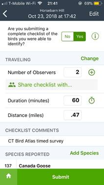
If you are an eBird user, then submitting data is simpler in several ways and makes it much easier for us to get data directly into the atlas database. There are, however, a couple of pitfalls to watch for. Make sure that the checklist is located at a point that is representative of the area you searched (e.g., the start point or a point in the center of the area covered); that the point and the entire surveyed area lies within your block (this can be especially problematic if you use existing eBird hotspot markers, see the bottom of this page); and that you submit the data as a travelling checklist (if you use the eBird app and set it to “Record track”, it will determine the distance you travelled automatically). Please also write “CT Bird Atlas timed survey” in the comments box for the checklist and then share with the ctbirdatlas account in eBird.
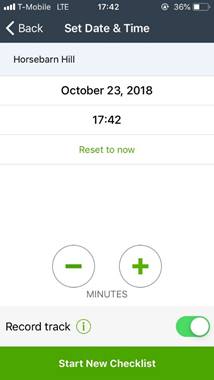
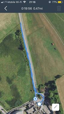
Survey distance: To record the distance covered while doing your survey, select “Record track” when you start the checklist, as shown at the bottom of the image on the left below. Doing this will also allow your phone’s GPS to record the path you take, as shown by the blue line on the image to the right, and requires that you have your phone’s location services turned on. To get an accurate distance estimate you should start the checklist right at the beginning of the survey and end it when the hour is up.
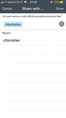
Sharing your checklist: Once you have finished collecting data, but before you submit the checklist, write the type of survey in the Checklist Comments box (near the bottom of the screen in the image on the left, below). From this screen you can also share the checklist directly with the atlas project – simply change the number of observers to 2 and then click on the green text that says “Share checklist with …” (see left image, below). You will see a new screen where you can enter the name of the account you want to share the checklist with (ctbirdatlas). The first time you share with a given account you will have to type in the account name. After that, however, just select the name from the “Recent” list, as shown in the image to the right, below. The ability to share directly from the phone app was a new feature in the fall of 2018, and may not show up if you do not have the most recent version of the app.
If you forget to add the survey type to the checklist comments, or to share the checklist before you submit it, you can make these changes by editing the checklist using eBird’s web interface through your computer’s browser.